
 NEMO
issued a warning on the afternoon of Sunday, October 7th that Hurricane
Iris could hit the Toledo District of Belize.
NEMO
issued a warning on the afternoon of Sunday, October 7th that Hurricane
Iris could hit the Toledo District of Belize.By 11:00 am Monday, NEMO announced that Hurricane Iris was going to make landfall between Dangriga and Monkey River.
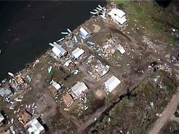
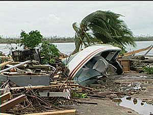
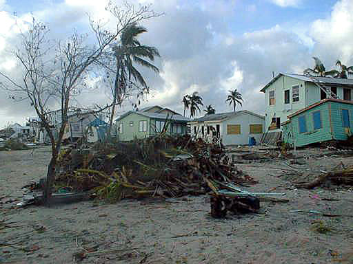
Why, then, did Captain Philip Martin proceed directly to Big Creek Harbor, effectively "ground zero"for the Category Four hurricane?
12:00 pm Sunday, October 7, 2001:
NEMO has declared the preliminary phase of the disaster management plan for Belize as Hurricane Iris continues to move in a westerly direction and may threaten the northern coast of Belize.
5:44 pm Sunday, October 7, 2001:
NEMO Extends Hurricane Watch from Belize City southward to the Toledo District as Hurricane Iris continues its westward movement with a chance it may move south of due west.
8:37 pm Sunday, October 7, 2001:
NEMO Declares Phase II, Red I Hurricane Watch for the entire country of Belize. Hurricane Watch is upgraded to a Hurricane Warning
6:00 am Monday, October 8, 2001:
Hurricane Iris is upgraded to a Category Four hurricane with winds in excess of 140 mph, and is considered extremely dangerous.
11:00 am Monday, October 8, 2001:
The Prime Minister and NEMO received a special briefing from Chief Meteorologist Carlos Fuller, who emphasized the seriousness of the threat posed by Hurricane Iris. On its present track, Iris is projected to make landfall early tonight somewhere between Dangriga and Monkey River. All people living in coastal areas or near river banks in the Toledo and Stann Creek districts are ordered to evacuate.

- The National Emergency Management Organization (NEMO) was
established in February of 1999, as the result of government's
immediate response to the aftermath of Hurricane Mitch, which
threatened Belize and ravaged Central America. (PDF 280
kb)
- NEMO is 'responsible for Emergency Management countrywide and the coordination of all International assistance in the event of a disaster, During the 'non-crisis periods', the NEMO Secretariat is responsible for the development, refinement and exercising of all Emergency plans. Training is conducted throughout the year in all aspects of Disaster Preparedness.
- In April, 1999 the National Disaster Plan for Belize (Volume 1 - Hurricane Preparedness) was updated and published. This was followed in May, 1999 with a Countrywide Simulation Exercise dubbed "EXERCISE MILLENNIUM BREEZE', which was designed to test the newly developed plans.
Hurricane Tracking
Advisories are numbered consecutively for each storm. Present location and intensity is described and expected movement is given. Tropical cyclones advisories are issued at six-hour intervals - at midnight, 6:00am, 12:00pm (noon) and 6:00pm Eastern Daylight Time.
Each message gives the name, centre (eye) position, intensity and forecast movement of the tropical cyclone. Hurricane centre positions are given by latitude (for example 13.5 degrees north) and longtitude (for example 55.0 degrees west).
When the storm moves within range of radars, centre position
may also be given as statute miles and compass direction from a
specified point. Tropical cyclones are not given names until they reach
the storm stage - that is, rotary circulation, and constant winds over
38 mph (33 knots).
When you receive a tropical cyclone advisory, note the advisory number,
centre position, intensity and forecast direction of movement. Mark the
centre position on the tracking chart. Because hurricanes change
direction very quickly, you should listen more carefully to where the
storm will go than where it has been.
NEMO's
Hurricane Preparedness
Guidelines
Belize National Emergency Management Organization (NEMO)


